|
|
Mnd-
|
Brk-
|
JrhRd- |
Jrh- |
NDand- |
Mund
Loop |
JohnF |
Oak- |
Nang-
|
Nang-
|
Will-
|
Strom-
|
Myl-
|
Ham |
Pile- |
SW- |
Clay- |
Nan- |
Will- |
OTB- |
Mnj- |
Pemb- |
Nthc- |
Shan- |
Frn- |
Rwy- |
Walp- |
VGRd- |
RomRd-ScotsRd |
ScotsRd-Denmark |
Denmark-Bornholm
|
Bornholm-Albany
|
||
|
|
Quin- |
|||||||||||||||||||||||||||||||||
|
Distance (Speedo) (km) |
49.9 |
30.7 |
25.9 |
32.8 |
31.76 |
|
42.1 |
35.75 |
30.7 |
30.7 |
31.5 |
37.0 |
55.56 |
33.3 |
37.1 |
31.4 |
53.5 |
25.7 |
- |
29.7 |
44.0 |
41.08 |
44.09 |
- |
- |
47.6 | - |
39.3 |
- |
- |
- |
- |
36.3 |
|
|
Distance (GPS) (km) |
46.7 |
29.6 |
25.3 |
31.6 |
29.83 |
19.5 |
41.9 |
33.72 |
28.6 |
28.7 |
29.9 |
33.1 |
54.9 |
32.7 |
35.9 |
31.01 |
53.0 |
25.1 |
32.2 |
29.5 |
43.9 |
40.8 |
43.14 |
34.4 |
33.8 |
47.2 |
8.3 |
38.8 |
36.6 |
40.6 |
37.7 |
41.3 |
36.3 |
|
|
Terrain Distance (GPS) (km) |
42.0 |
34.04 |
28.94 |
29.11 |
30.3 |
33.5 |
55.0 |
32.8 |
35.9 |
31.03 |
54.1 |
25.1 |
32.2 |
29.6 |
44.2 |
40.85 |
43.19 |
34.4 |
33.9 |
47.2 |
8.3 |
38.9 |
36.7 |
40.7 |
37.9 |
41.3 |
36.3 |
|||||||
|
Riding Time (hh:mm) |
3:51 |
2:14 |
1:36 |
2:37 |
2:30 |
|
3:00 |
2:46 |
1:57 |
2:02 |
2:40 |
2:35 |
4:19 |
3:04 |
2:23 |
2:25 |
3:38 |
1:52 |
2:18 |
2:15 |
3:01 |
2:48 |
3:24 |
2:33 |
2:49 |
3:43 |
0:33 |
2:52 |
2:59 |
2:54 |
2:24 |
2:34 |
2:10 |
|
|
Elapsed Time (hh:mm) |
5:42 |
3:22 |
2:19 |
4:38 |
3:35 |
2:30 |
3:40 |
3:44 |
2:37 |
2:42 |
3:45 |
3:23 |
5:39 |
5:02 |
3:08 |
3:36 |
5:36 |
2:29 |
3:35 |
3:32 |
5:19 |
4:13 |
5:37 |
4:01 |
3:47 |
5:52 |
0:33 |
4:30 |
4:06 |
4:17 |
3:32 |
3:32 |
2:46 |
|
|
Rest Time (hh:mm) |
1:51 |
1:08 |
0:43 |
2:01 |
1:05 |
|
0:40 |
0:58 |
0:40 |
0:40 |
1:05 |
0:48 |
1:20 |
1:58 |
0:45 |
1:11 |
1:58 |
0:37 |
1:16 |
0:47 |
2:17 |
1:24 |
2:13 |
1:28 |
0:58 |
2:09 |
0:00 |
1:38 |
1:06 |
1:23 |
1:08 |
0:58 |
0:36 |
|
|
Avge Riding Speed (kph) |
13 |
13.6 |
16.1 |
12.4 |
12.6 |
14 |
12.9 |
15.6 |
15.0 |
11.7 |
14.6 |
12.8 |
10.7 |
15.0 |
12.8 |
14.7 |
13.2 |
14.0 |
13.1 |
14.6 |
14.6 |
12.7 |
13.4 |
12.0 |
12.7 |
14.7 |
13.5 |
12.3 |
14.0 |
15.7 |
16.0 |
16.7 |
||
|
Overall Avge
Speed (kph) |
8.2 |
8.8 |
10.9 |
6.8 |
8.3 |
7.8 |
11.4 |
9.0 |
10.9 |
10.6 |
8.0 |
9.8 |
9.7 |
6.5 |
11.5 |
8.6 |
9.5 |
10.1 |
9.0 |
8.3 |
8.3 |
9.7 |
7.7 |
8.6 |
8.9 |
8.0 |
14.7 |
8.6 |
9.0 |
9.5 |
10.7 |
11.7 |
13.1 |
|
|
Rest Time / Riding Time |
21% |
36% |
45% |
77% |
43% |
22% |
35% |
34% |
33% |
41% |
31% |
31% |
64% |
31% |
49% |
54% |
33% |
55% |
35% |
76% |
50% |
65% |
58% |
25% |
58% |
0% |
57% |
33% |
32% |
32% |
38% |
22% |
||
|
Total Height Climbed (m) |
1407 |
1053 |
784 |
786 |
866 |
680 |
821 |
1428 |
1409 |
1555 |
1354 |
1442 |
475 |
650 |
328 |
308 |
270 |
412 |
337 |
405 |
412 |
474 |
450 |
402 |
420 |
647 |
18 |
600m |
401 |
495 |
356 |
125 |
125 |
|
|
Total Height Descended (m) |
1193 |
976 |
828 |
851 |
882 |
720 |
750 |
1446 |
1272 |
1525 |
1410 |
1503 |
516 |
569 |
547 |
210 |
359 |
244 |
405 |
287 |
569 |
477 |
486 |
448 |
400 |
683 |
58 |
596m |
332 |
500 |
414 |
101 |
179 |
|
|
Highest to Lowest (m) |
350 |
202 |
254 |
199 |
181 |
210 |
285 |
170 |
300 |
280 |
230 |
290 |
138 |
190 |
259 |
100 |
112 |
265 |
127 |
167 |
196 |
104 |
131 |
98 |
130 |
192 |
49 |
214 |
128 |
117 |
224 |
69 |
104 |
|
|
Total Distance Climbing (km) |
21.4 |
13 |
11.5 |
15.2 |
11.9 |
9.02 |
21.6 |
14.6 |
13.8 |
12.8 |
13.4 |
14.7 |
19.3 |
18.6 |
18.0 |
19.0 |
11.5 |
15.3 |
16.9 |
15.6 |
18.1 |
20.6 |
13.6 |
17.5 |
15.3 |
24.4 |
0.4 |
17.1 |
19.2 |
22 |
20.3 |
35.5 |
12.1 |
|
|
Total Distance Descending (km) |
25.7 |
16.8 |
13.9 |
16.5 |
17.9 |
10.6 |
20.4 |
19.4 |
15.1 |
16.3 |
16.9 |
18.7 |
34.3 |
13.6 |
17.5 |
10.1 |
39.4 |
9.4 |
14.5 |
10.8 |
24.8 |
19.2 |
26.6 |
16 |
17.1 |
20.6 |
7.0 |
18.2 |
16.6 |
17.9 |
17.0 |
5.0 |
23.3 |
|
|
Waypoint files |
|
|
|
|
|
|
|
|||||||||||||||||||||||||||
|
Google Earth track |
view | view | view | view | view | view |
view |
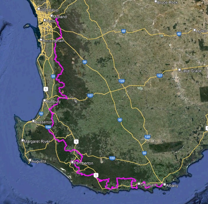
Map of rides done to-date view rides done to-date in Google Earth
Mnd-Brk = Mundaring to Brookton Highway
Brk-JrhRd = Brookton Highway to Jarrahdale Road
JrhRd-Jrh = Jarrahdale Road to Jarrahdale
Jrh-Ndand = Jarrahdale to North Dandalup dam picnic area
NDand-Oak = North Dandalup Dam top car park to Oakley Dam
Mund Loop = Mundaring Loop (with some detours & repairs!)
Oak-Nanga = Oakley Dam to Nanga
Nang-Will = Nanga to Willowdale Arboretum
Will-Strom = Willowdale Arboretum to Stromlo Rd
Strom-Myl = Stromlo Rd to Myles Ave (south intersection) (Note: wrong route taken near the southern end)
JohnF = John Forest Heritage Trail (inc detour to Mundaring Bakery!)
Myl-Coll = Myles Ave to Collie
Ham-Pile = Hamilton Rd / Wallis Ave to Pile Rd (Included 0.9 km ride to the start)
Pile-SW = Pile Rd to SW Highway / Bendale Rd junction
SW-Clay = SW Highway / Bendale Rd junction to Claymore Rd
Clay-Nan = Claymore Rd to Jarrahwood, then to Nannup via the Old Timberline Trail (includes 2km wrong-way)
Nan-Will = Nannup to Willow Springs
Will-OTB = Willow Springs to One Tree Bridge
OTB-Mnj = One Tree Bridge to Manjimup
Mnj-Quin = Manjimup to Quinninup
Quin-Pemb = Quinninup to Pemberton
Pemb-Nth = Pemberton to Northcliffe
Nth-Shan = Northcliffe
to Shannon River
Shan-Frn = Shannon River bridge to Fernhook Falls
Frn-Rwy = Fernook Falls to Railway Parade
Rwy-Walp - Railway Parade to Walpole
Walp-VGRd = Walpole to Valley of the Giants Rd (eastern crossing) (Note: 1.4km going in a circle at the start!)
VGRd-RomRd
= Valley of the Giants Rd to Romance Rd
RomRd-ScotsRd = Romance Rd to Scotsdale Rd
ScotsRd-Denmark = Scotsdale Rd to Denmark